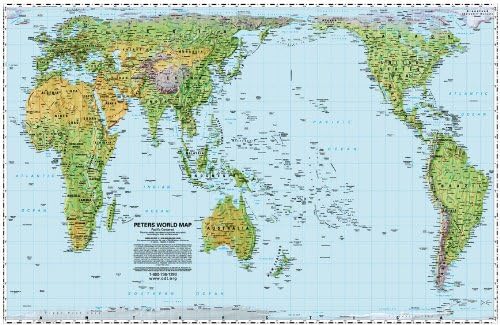
This map brings your visual focus onto the oceans instead of the land and feels quite different from the Africa-centered Peters Map. This map will challenge students to think about the world, and USA-centrism, in a whole new way, providing an entree into many topics of discussion. This Pacific-centered version is color-coded as a physical relief map showing mountain ranges, different types of terrain, etc. It uses a proprietary technique of Oxford Cartographers known as 3-D hill-shading. Important features of the Peters Map: The Peters Map is an equal area map; the map shows all areas - whether countries, continents or oceans - according to their actual size. Accurate comparisons become possible; on the Peters Map all North-South lines run vertical on this map. Thus, geographic points can be seen in their precise directional relationship