Restoration Cartographic Wall Map of Flathead Lake - Vintage Shaded Relief Print, 2D Topographic Wall Art for the Home or Office, Lakes Maps, 12 x 18
$15.99
by Restoration Cartographic
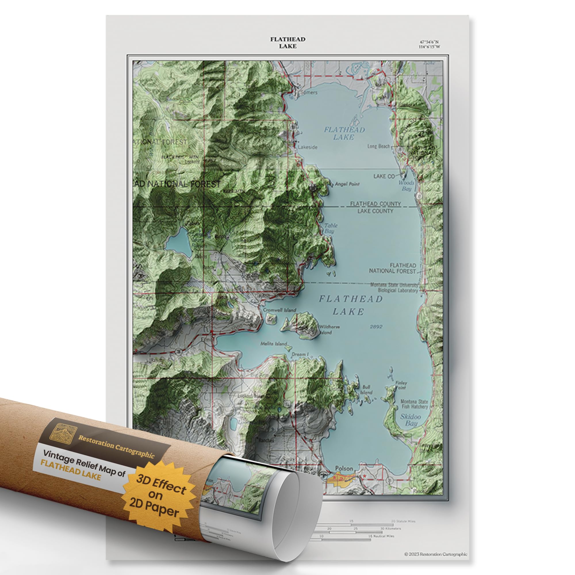
2D PRINT WITH 3D EFFECT: This is a flat paper print, not a raised or physical 3D map. Using advanced shading techniques, we create the illusion of sculpted terrain on two-dimensional poster. The result is visually striking but completely smooth to the touch and easy to frame MAPS OF THE WORLD: Discover the topographic and historical charm of Flathead Lake with this meticulously restored 1957 Flathead Lake map, originally commissioned by the United States Geological Survey. Part of our Vintage Series, this 2D print showcases the lake's intricate topography and landmarks in exquisite detail, making it a unique and captivating piece of both history and art DIGITAL SHADOWING FOR ARTISTIC EFFECT: After restoration, our designers apply shadows across the vintage map to simulate natural light and elevation, creating a 3D-like illusion. Because this is designed as wall art, not a reference map, some text labels may be partially obscured or distorted up close—prioritizing visual depth over functional detail WALL-MOUNTED MEMORIES: More than a map, Restoration Cartographic posters tell a visual story—of home, travel, or your favorite place on earth. We bring beauty and meaning to your walls, whether in a cozy cabin, sleek office, or creative studio, enhancing your decor with a blend of historical cartography and artistic elegance AVAILABLE IN THREE SIZES: Choose from 12 x 18", 20 x 30", or 24 x 36" to fit your space. Printed on premium matte photographic paper for rich color and sharp contrast; ideal for framing and gifting. Also available: Countries Series, American States Series, American Islands Series, American Lakes Series, Minimalist Series. Restoration Cartographic Flathead Lake Restored Vintage Relief Maps: Where Artistry and Geography Converge. Immerse yourself in the captivating illusion of depth with our Shaded Relief Maps, brought to you by Restoration Cartographic. This 12 x 18-inch map picture of Flathead Lake beautifully captures the lake’s natural grandeur through detailed topography and expert craftsmanship. Whether you're looking to complement your lake Lucerne wall art map collection or seeking an authentic piece of American geography, this print makes a lasting impression. Drawn from antique government archives and inspired by works like the Missouri cartographic map and map Mississippi River, this restored print showcases Flathead Lake’s shoreline, forested surroundings, and the pathways that define the region’s history. Its style resonates with the expansive scale of a relief map of the western United States, making it a perfect companion for those who admire national landscapes. This print also blends beautifully with broader geographical decor—such as a public land wall map or a topographical map picture 3D of CA—offering both aesthetic value and educational appeal. Enhanced with digital shading techniques, each Flathead Lake print captures light and elevation with subtle shadows that give depth to terrain. Whether displayed alongside a county area Los Angeles map or used as a standalone statement piece, it delivers a textured, three-dimensional experience on paper. Celebrate America’s diverse landscapes with a refined artwork that bridges history, place, and artistry—crafted to transform your space and elevate your connection to the land