StreetSmart® Oaxaca Map by VanDam -- Laminated State, Region and City Map to Oaxaca, Mexico with all attractions, sights, museums, mezcalerias, hotels
$9.95
by Stephan Van Dam
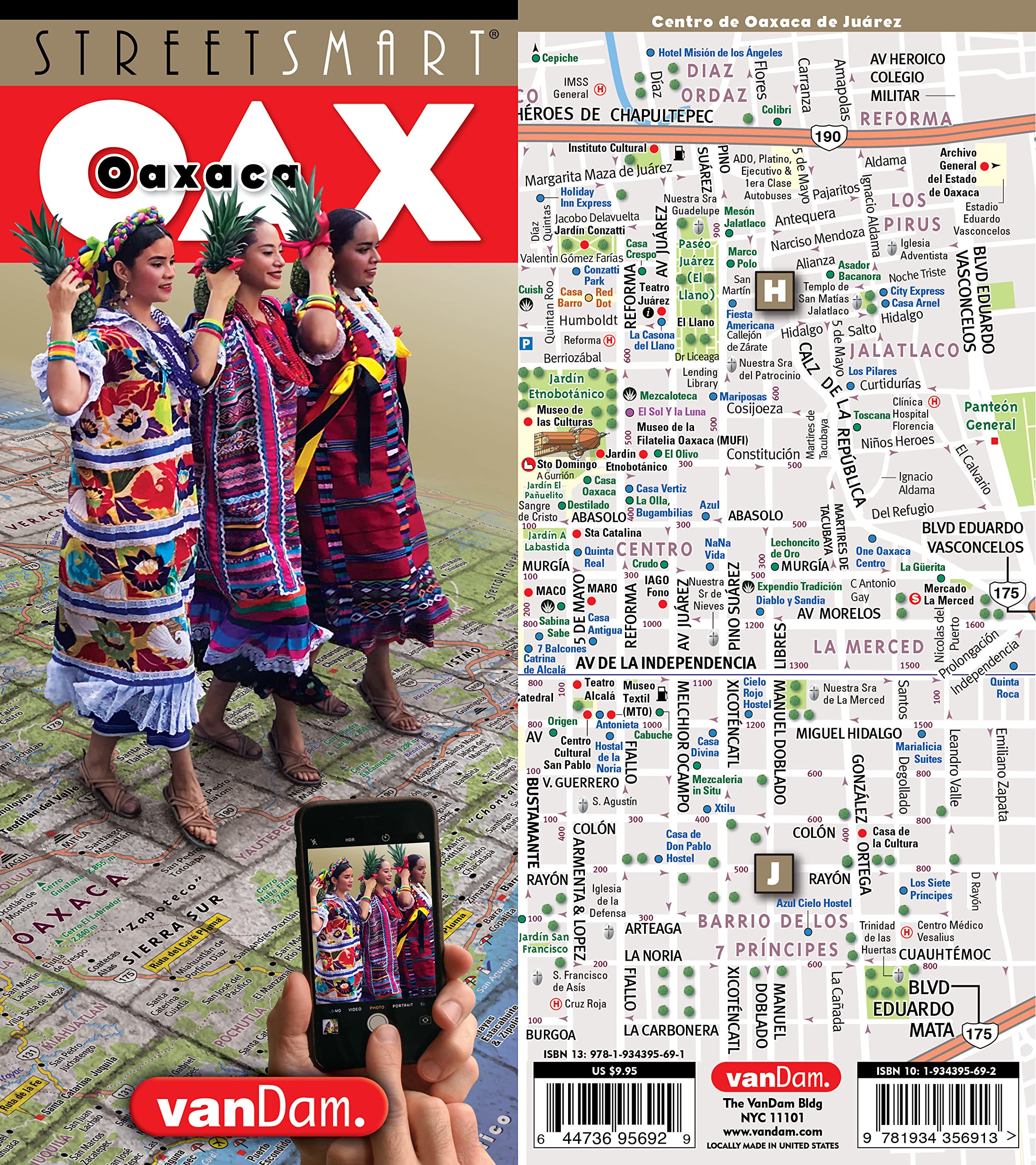
Oaxaca description: VanDam's news 2023 STREETSMART® Oaxaca maps all top attractions, archeological sites, museums, colonial churches, artisanal market towns, hotels, restaurants, mezcal bars, and ecotourism sites at an immensely legible scale complete with 3-D relief of the Sierra Madre mountains. Clear information design allows users to read the map from three feet away and has earned VanDam maps a place in the MoMA Collection . The map is film-laminated, accordion folded and pocket-size. Coverage: Oaxaca State Map 1:1,500,000; Valles Centrales Map: 1:230,000; Oaxaca City Map: 1:11,000; Puerto Escondido Map: 1:10,000; Puerto Angel Map: 1:10,000; Huatulco Map: 1:11,000; Monte Albán Map: 1:3,600; Dimensions: 4 x 9 folded, 9 x 24 unfolded, fits into shirt pocket or purse. STREETSMART® Oaxaca is so legible you will instantly understand how the regions, main highways, and towns connect from the artisanal villages in the Valles Centrales to the Afromexicano communities & superb surf beaches of the Costa Chica, from the matriarchal culture of the Istmo to the baroque Dominican churches in the Mixteca and the cloud forests of the Papaloapám. STREETSMART® Oaxaca focuses in from God's perspective to the most minute details with eleven recommended drives: Ruta de Mezcal, Artesanal, Biósfera, Café, Chinantla, Costa, Ecotourism, Mazateca, Mixe, Mixteca, and Ruta de la Fe. The 15 major languages are mapped as is a list of the best in archeological sites, baroque churches, pottery and weaving communities, ecotourism, magic mushroom destinations, coffee plantations, mezcal towns and more to help you make the right decisions. For surfers and beach goers all major Pacific beaches are listed and rated.In Oaxaca's capital city, Oaxaca de Juárez, you may find yourself on the Alcalá in Centro Historico looking for restaurant Origen to taste Lechon with Chicatanas (suckling pig with peppery ants). You want to visit Monte Albán, the famed Zapotec mountain top city, to decipher its meaning as a piece of architecture and its astronomical connection to the heavens above. This map reveals the geometry of the sky and how the Zapotecos designed their capital to bring it down to earth. You might attend a cooking class with Susana Trilling which means pointing out on the map to a cabdriver how to get to Seasons of my Heart in San Lorenzo Cacaotepec in the Etla Valley. When you are ready for rug shopping and are looking for the best route to get from Centro to the market town of Teotitlán del Valle for its Monday market with an excursion to the mezcalerias in San Bartolo Albarradas on the Ruta de Mescal and/or an afternoon rest stop at Hierve de Agua, the ecotourism site down the road, STREETSMART Oaxaca is your tool. STREETSMART® Oaxaca makes it all clear and understandable. You are ready to bike or hike up in the Sierra Norte de Oaxaca (SNO) at 3,000 meters (9,842 ft) immersed in maguey plants the size of cars while looking down at the clouds to coincide with the local mushroom festival (August). This map will give you the shortest and most scenic route to get there and back with confidence. Even though you may have a tour lined up and only need to follow the person in front of you this map will give you an insight into the unparalleled botanical, archeological and cultural riches that are Oaxaca. This map makes it easy and you are an instant Oaxaqueña. Stephan Van Dam, the map's designer and publisher splits his time between NYC and Oaxaca and has lived in the Etla Valley of Oaxaca part of the year for the last 6 years. STREETSMART® Oaxaca is updated twice a year. "The Map to Oaxaca" --The New York Times "A Magical Series" --Travel & Leisure Magazine "The best innovation in map design since the globe was flattened onto paper." --Diversion Magazine Stephan Van Dam is an award-winning cartographer, graphic designer, and information architect. He is the publisher and creative director of New York-based VanDam, Inc. The universal power of maps has been his guiding passion for the past 35 years and fuels his desire to tell stories and construct new realities through maps in all media. VanDam publishes maps to 125 cities worldwide in five unique formats: StreetSmart, Pop-up, UNFOLDS, @tlas and 4DmApp all of which are highly legible, up-to-date and come in sexy, irresistible packages. Van Dam holds several patents in the field of paper engineering and origami map folding. His work has been honored by the Industrial Design Society of America (IDSA), the American Institute of Graphic Arts (AIGA), the editors of ID magazine and has been featured on national television and in numerous feature films. Twenty six of VanDam's origami-folding maps are in the MoMA Collection. He presented his 4DmApp at the original TED conference in 2002.