StreetSmart® USA Western Interstate Road Map by VanDam ― Eco plastic coated, planning & travel map of the USA w/all federal, state hwys, attractions &
$10.95
by Stephan Van Dam
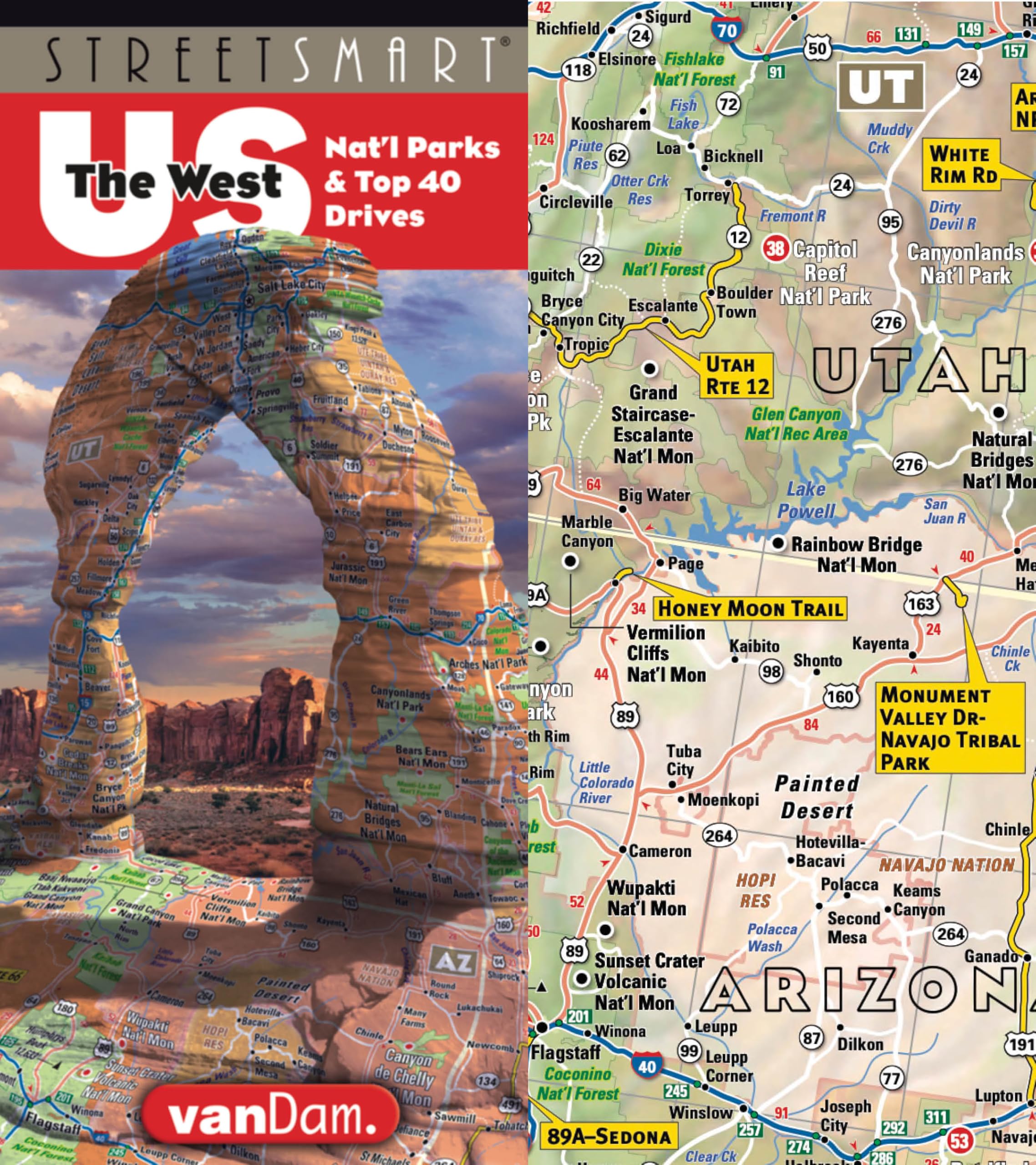
StreetSmart® USA Western Interstate Map by VanDam features all the top attractions, national parks, -forests, -monuments, museums, theme parks, engineering marvels, natural treasures, and holiday destinations, PLUS individual driving guides to the top 40+ scenic routes & describes all National Parks from American Samoa to Texas: 2026 Road Smart Edition Dimensions: 40” x 27” open, 9” x 4” closed to fit into your pocket and glove compartment. This high-quality, eight-color map is printed on waterproof, tear resisted, synthetic Poly Art plastic stock which refolds easily without tearing and stands up to grease, weather and chemicals. A keeper. Contents: Main Continental USA Western map scale: 1:2,850,000; Alaska map detail 1:23,000,000; American Samoa detail: 1:350,000; Hawaiian Islands detail: 1: 3,500,000; USA West Mileage Distances Chart, Western USA Milage and Distances Map. StreetSmart® USA “Best of the West” Interstate Map by VanDam accurately shows all cities, points of interest, state and country boundaries, mountain ranges, and is easy to read from three feet away which has earned VanDam maps a place in the MoMA Design Collection. VanDam is a trusted brand with superior data and information design. You will instantly understand the interstates system and how it connect with state roads and which Top 40+ Scenic Byways are close by on your cross country or weekend escape trips to catch a special scenic detour or plan a driving vacation. An essential travel tool in your car, and a beautiful piece of graphic art on your wall as a rolled poster. The USA West Mileage Distance Chart makes it easy to determine and plan driving distances while the USA Mileage and Distances map relates travel time and distances for easy and reliable navigation. StreetSmart® USA Best of the West Interstate Map by VanDam Here is a sampling of the Top 40+ Drives & Nat’l Parks Ecotopia Drive: To savor the Pacific North West with its dramatic coastal rainforests start with a feast of alder-smoked salmon at Seattle’s Pike Place Market, then drive through the temperate and lush rainforests of Olympic National Park listening to the sounds of the ocean at La Push with a massage and/or overnight stop at Sol Duc Hot Springs before heading down the Oregon coast with the ocean on your right toward Northern California. Possible side trips might include the Farmland Tour and Powell’s Books, the country’s largest independent ― as you wend your way through Ecotopia to Redwoods National Park just over the Northern California state border. A once in a lifetime adventure. Total mileage: 620 (997 kms) allow 3-5 days. God’s Country: Utah’s Scenic Byway 12 from Panguitch to Torrey offers the most stunningly beautiful and divine landscapes on Earth: Start at Zion Nat’l Park, proceed to Bryce Canyon, Grand Staircase Escalante Nat’l Mon, then Glen Canyon Nat’l Park and finish at Capitol Reef Nat’l Park, all within an easy 123 mile (197.5) km drive. StreetSmart® USA Best of the West Interstate Map by VanDam Here is a sampling of our Nat’l Park Guides.
So you know why, when and how to visit. Big Bend Nat’l Park, TX
Where the Rio Grande (Rio Bravo in México) bends north birders go to heaven. Part of the Chihuahuan desert it offers rivers, desert and mountain landscapes plus 500 million years of geologic change. Stay in Terliunga or the art town of Marfa. Gates of the Arctic, AK North of the Arctic Circle lies this ancient, archetypal land primarily alpine tundra, the heart of Alaska, populated by black bears, grizzlies, dall sheep, moose, oxen and wolves. You fly or hike in as there are no roads. Great Sand Dunes, CO Wind, water + time = sand. 11,000 years ago the Clovis people roamed over these tallest dunes in North America. Head to the Dunefield to experience Star Dune (755 ft) at dawn or dusk for magical light play. Remember you are at 8,700 ft elevation. North Cascades, WA The . American Alps are one of the youngest ranges (2million years) in the US and a still intact ecosystem. Fire & Ice. Rugged & remote HWY WA 20 is the only way in, then trails abound. Catch the glaciers while they last and Be the Change. So get the new 2026 StreetSmart® USA Interstate Map by VanDam to discover the magic drives only the USA can offer! "The Map to the Western USA" The New York Times "A Magical Sereies of Maps" Travel & Leisure "The best invention in map design since the globe was flattened onto paper" Diversion Eco Poly Art Plastic cover stock to resist water, tear and chemicals. Easy to fold Stephan Van Dam is an award-winning cartographer, graphic designer, and information architect. He is the publisher and creative director of New York-based VanDam, Inc. The universal power of maps has been his guiding passion for the past 40 years and fuels his desire to tell stories and construct new realities through maps in all media. VanDam publishes maps to 100+ cities worldwide in five